
You are currently browsing the category archive for the ‘Volcanos’ category.
Please see the Icelandic Met Office for more recent information…
and some external related links…
http://baering.github.io/
This link is to a developmental visualization project of the creator of the link above – pretty spectacular…
earthquakes visualization in near real time
http://www.ruv.is/volcano
http://en.vedur.is/earthquakes-and-volcanism/articles/nr/2947
Bárðarbunga 2014 – recent earthquakes
Continually updated maps
In this article, the most recent earthquakes at Bárðarbunga are given by maps that are updated more or less continuously. Each earthquake is represented by a circle. The size of the circle indicates the magnitude. The timing is colour coded, see the bar to the right of each map. The first two maps show earthquakes counting hours since midnight but the third one shows earthquakes since the onset of this seismic event (counting days). The date and timing of each map is in the lower right hand corner (yyyymmdd 00:00).
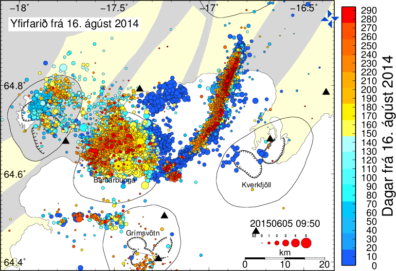
Manually processed earthquakes since midnight:

Automatic recording of earthquakes since midnight:


Bárðarbunga earthquakes in 3D
Three dimensional video 16-20 August 2014
The Bárðarbunga seismic activity can now be explored in a three dimensional video (30 sec.) which shows earthquakes from 16th to 20th August 2014.
Location, depth and age of earthquakes in Bárðarbunga 16-20 August 2014.
The colour of the dots implies the date: First there are red dots, then orange, yellow, light-green and then green. Please note that height and depth are exaggerated five times in order to show the topography explicitly and to expand the space between the earthquakes at depth.
The magnitude of the earthquakes is not shown; all dots are of equal size in this video. The same dots are shown on the surface as at depth for better harmony between the two. The depth of the earthquakes is indicated by the horizontal planes which are set at 0 km, 5 km and 10 km depth below sea level.
IMO’s specialist, Bogi B. Björnsson, compiled this video from the available data.
Bárðarbunga – updated information
Overview of seismic events in August 2014
In this article, updated information on the Bárðarbunga seismic activity is given with daily status reports from the scientist of IMO and the University of Iceland. New material is added to the top of the article. The original information is at the end of the article. All in all, this article gives an overview of events. For additional material, check also the news list on our front page.
23rd August 2014 14:10 – a small eruption under Dyngjujökull
A small lava-eruption has been detected under the Dyngjujökull glacier.
The Icelandic Coast Guard airplane TF-SIF is flying over the area with representatives from the Civil Protection and experts from the Icelandic Met Office and the Institute of Earth Sciences. Data from the equipment on board is expected later today.
Data from radars and web-cameras is being received, showing no signs of changes at the surface.
The estimate is that 150-400 meters of ice is above the area.
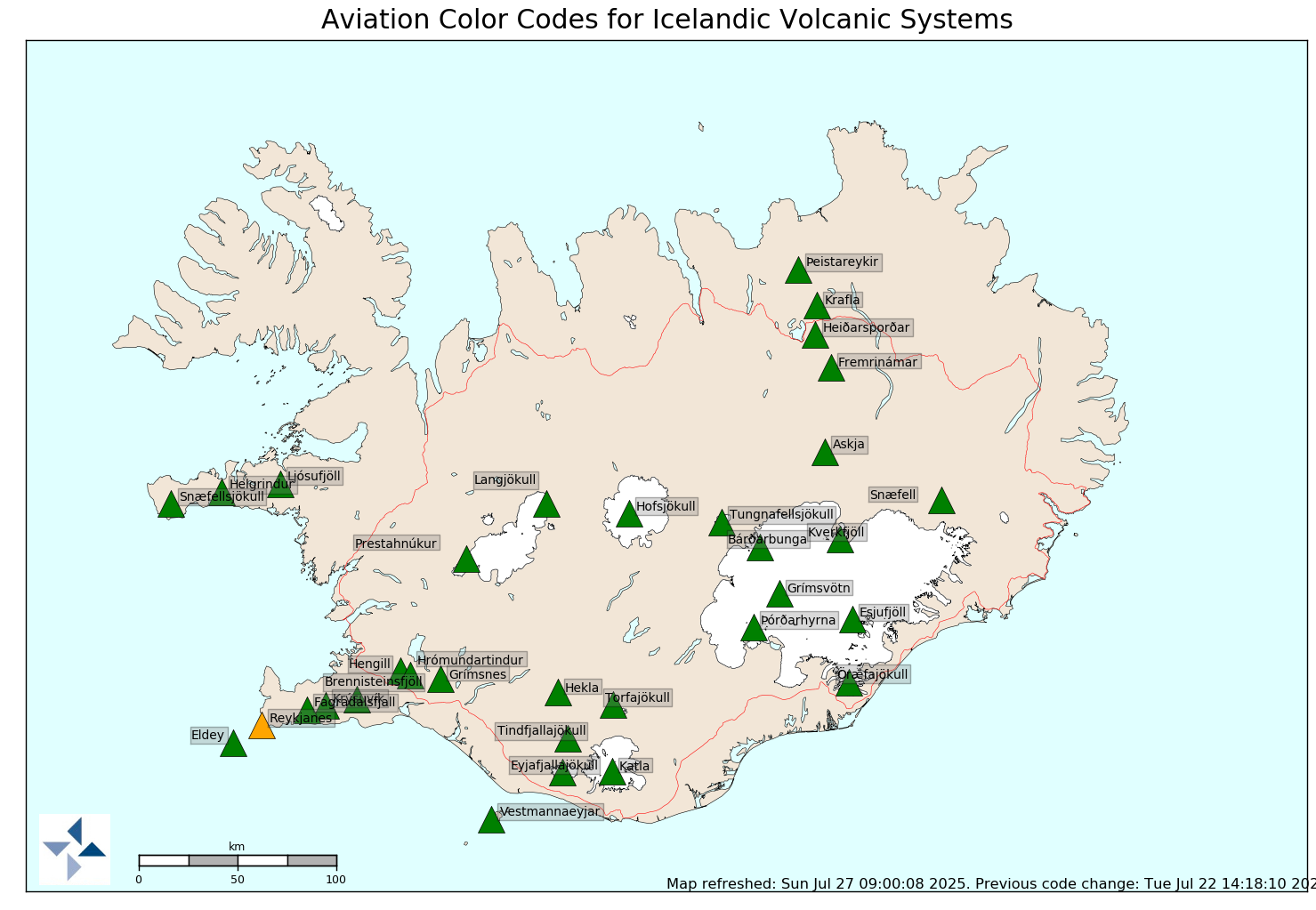
The aviation color code for the Bárðarbunga volcano has been changed from orange to red.
Some minutes ago (14:04), an earthquake occurred, estimated 4.5 in magnitude.
23rd August 2014 12:20 – notes from the scientists’ meeting
Intense earthquake activity continues at the Bárðarbunga volcano – a situation that has persisted since 16 August.
During the last 6 hours the dyke has propagated ~5 km to the north. The rate of earthquakes has increased such that they are happening so quickly that it is difficult for the seismologist to discern individual events. Observed high frequency tremor is interpreted to be caused by the propagation of the dyke.
Some larger earthquakes of magnitude 3 – 4 have been measured in the Bárðarbunga caldera in the last days. These events in the Bárðarbunga caldera are interpreted as adjustments related to decompression in the caldera since the beginning of the unrest.
Most recent GPS data shows that magma flow is continuing.
The Coast Guard TF SIF aircraft is taking off by 13:00 to make observations with scientists from Icelandic Met Office, the Institute of Earth Sciences, and people from the Civil Protection.
A tourist plane called in at noon to report no visible changes at the surface.
Current winds: weak winds at low levels. At higher levels winds are northerly (towards the south).
Hydrological measurements at Jökulsá á Fjöllum, Upptypingar, do not indicate a contribution of geothermal/volcanic gases to the hydrological system that is outside of the typical range observed in the last decade.
The activity continues and an eruption can therefore not be ruled out.
The aviation colour-code for the Bárðarbunga volcano remains unchanged at ‘orange’, and we are continuously evaluating if this should be changed. The volcano is exhibiting heightened levels of unrest.
22nd August 2014 17:00 – status report
Overall assessment from the joint daily status report 220814 of the Icelandic Met Office and the University of Iceland, Institute of Earth Sciences:
There are no measurements to suggest that an eruption is imminent. Previous intrusion events in Iceland have lasted for several days or weeks, often not resulting in an eruption. However an eruption of Bárðarbunga cannot presently be excluded, hence the intense monitoring and preparation efforts. The ongoing monitoring and assessment effort is necessary in case a volcanic eruption occurs. Hazards in the event of an eruption are being assessed, including a glacial outburst flood and dispersal of volcanic ash. Additional seismic, GPS and hydrological stations have been installed in the Bárðarbunga region. Likewise, mobile radars capable of monitoring ash dispersal have been moved to the region. The aviation colour-code for the Bárðarbunga volcano remains unchanged at ‘orange’, signifying that the volcano is exhibiting heightened levels of unrest.
Bárðarbunga
“”
View to Bárðarbunga. Web camera M&T ehf.
22nd August 2014 13:00 – notes from the scientists’ meeting
Intense earthquake activity continues at the Bárðarbunga volcano – a situation that has persisted since 16 August. There are no signs that the seismicity is decreasing. A 25 km long dyke has formed in the crust under the Dyngjujökull glacier at 5-10 km depth. Interpretation of the latest data suggests that the magma continues to move along the dyke, possibly branching at the northeast end of the dyke.
One earthquake of magnitude 4.7 was measured in the Bárðarbunga caldera at 4 km depth yesterday evening at 23:50. This large event was at similar location as earthquakes of magnitude larger than three that were seen yesterday. Large events in Bárðarbunga are interpreted as adjustments of the caldera rim related to decompression in the caldera since the beginning of the unrest. The activity continues and an eruption can therefore not be ruled out.
There are no signs of increased conductivity through geothermal activity into the rivers.
From the beginning of the activity, measurements done with GPS have shown displacements on the surface of over 14 cm, 15 – 20 km from Dyngjuháls. In comparison, Iceland on the whole is spreading at the rate of about 2 cm pr. year.
A new GPS station in Kverkfjöll is now running and sending data. Similar seismic instruments were installed by Kverkfjöll yesterday, as well as close to the GPS station at Hamarinn, which was set up two days ago. In addition, two seismic stations set up in Dyngjujökull yesterday are collecting data on site. This work is done in collaboration between IMO, the Institute of Earth Sciences and collaborators in the European FutureVolc research project.
The aviation colour-code for the Bárðarbunga volcano remains unchanged at ‘orange’, signifying that the volcano is exhibiting heightened levels of unrest.
22nd August 2014 06:40 – from geoscientist on duty
Seismic activity in Bárðarbunga and Dyngjujökull is still great. It diminished somewhat after two o‘clock in the morning. Almost 400 quakes have been detected by the automatic network since midnight and, as in recent days, the majority of them is located east of Bárðarbunga, next to the intrusion. Most of the manually processed earthquakes turn out to be at great depth, 8-12 km, but a few at the very northeastern tip of the intrusion have been positioned at shallower depths, up to just under 4 km.
Just before midnight, 21st August at 23:50:22, an earthquake occurred at Bárðarbunga which measured 4.7-4.8 in magnitude. Another one reached M3. During the last days quite a number of quakes has been detected within the Bárðarbunga caldera, or on the rims, at a depth of 2-6 km. Probably these earthquakes derive from changes in pressure when magma is drawn eastward into the huge intrusion and away from the magma chamber under the caldera.
Jökulsá á Fjöllum
“”
This is where the cirle road around Iceland, road nr. 1, crosses river Jökulsá á Fjöllum, not far from farm Grímsstaðir á Fjöllum. This bridge might come under severe strain if the Bárðarbunga seismic phase leads to an eruption and a glacial outburst flood: A grave concern for the Icelandic Road and Coastal Administration. Just south of this bridge is a closed area for safety reasons. Photo: Þorsteinn Þorsteinsson.
21st August 2014 17:00 – status report
Overall assessment from the joint daily status report 210814 of the Icelandic Met Office and the University of Iceland, Institute of Earth Sciences:
There are no measurements to suggest that an eruption is imminent. Previous intrusion events in Iceland have lasted for several days or weeks, often not resulting in an eruption. However an eruption of Bárðarbunga cannot presently be excluded, hence the intense monitoring and preparation efforts. The ongoing monitoring and assessment effort is necessary in case a volcanic eruption occurs. Hazards in the event of an eruption are being assessed, including a glacial outburst flood and dispersal of volcanic ash. Additional seismic, GPS and hydrological stations have been installed in the Bárðarbunga region. Likewise, mobile radars capable of monitoring ash dispersal have been moved to the region. The aviation colour-code for the Bárðarbunga volcano remains unchanged at ‘orange’, signifying that the volcano is exhibiting heightened levels of unrest.
21st August 2014 15:00 – a few facts
Today, three earthquakes exceeding 3 in magnitude have occurred on the caldera rim of Bárðarbunga (M 3.7 at 10:29, M 4.0 at 10:58 and M 3.4 at 13:02). These earthquakes were at depths around 2 – 5 km. They are interpreted as possible adjustments of the caldera due to changing magma pressure – they are not assumed to be the precursor to an imminent eruption.
21st August 2014 12:00 – notes from the scientists’ meeting
No signs of diminishing activity around Bárðarbunga
An intrusion, 25 km long, has formed beneath Dyngjujökull, at a depth of 5-10 km
The aircraft TF-SIF, from the Icelandic Coast Guard, is now available for scientists
The aviation colour code is still orange
The seismic activity in Bárðarbunga, first noticed 16th August, has maintained its strength and there are no signs of its retreat. Deformation measurements, GPS, indicate that a 25 km long intrusion is forming underneath Dyngjujökull. Earthquake measurements support the conclusion that the magma is still at 5-10 km depth. There are no signs of upward migration of the activity.
Collateral interpretation of the latest data suggests that the intrusion is expanding at its northeastern end, whereas its length has only increased a little in the last 24 hours.
In the Bárðarbunga caldera, where it all started, earthquakes still occur; probably because of slight subsidence due to the outward flow of magma from the magma-chamber under the caldera.
The measuring network in the area is being improved; just now technicians from the Icelandic Met Office, from the Institute of Earth Sciences and from foreign research institutions are mounting additional equipment on the ice-cap and at its margin. Already, many devices which have been implanted in recent years as part of the international FutureVolc project, are running and providing important information which has been useful in both monitoring and analysis of these events.
Yesterday, a reconnaissance flight was made over the area with the Icelandic Coast Guard. The aircraft TF-SIF, now dedicated to these events, has specialised equipment on board for monitoring changes in the surface of the ice-cap and monitoring outburst floods. No signs of change were detected during this flight. With open access to this aircraft, which was withdrawn from its current tasks at the Mediterranean, scientist are now in a much better position to monitor possible volcanic activity and flooding.
Rumours are flying right now that volcano Katla in Iceland may be ready to blow. Increased seismic activity has observers on high alert to the possibility of a large eruption. Katla is a very large volcano that has erupted before.

Icelandic Met Office, Icelandic Institute of Earth Sciences
More than 500 tremors have been recorded in the last month. Sky News reports:
“A huge Icelandic volcano long overdue an eruption is showing signs of activity – threatening disruption to air traffic, experts have said.
There have been more than 500 tremors at Katla in the south of the country in just the last month. An increase in activity at the site since July has also been causing volcanologists concern, when increasing temperatures and seismic activity caused a flood, washing away a road bridge.
The last major eruption at the volcano was in 1918, and caused such a large glacier meltdown that icebergs were swept by the resulting floods into the ocean.
Significant activity at Katla – which has a huge 6.2 mile (10km) crater – usually occurs every 40 to 80 years. It is feared when it does eventually erupt, it could be the most powerful activity the country has seen in almost a century. Catastrophic flooding could result as the frozen surface of the volcano melts, sending vast amounts of water into the Atlantic Ocean.
Volcano expert Andy Hooper, from Delft University, said although there had been increased activity at the site, it was difficult to predict if and when Katla would erupt. However, he told Sky News Online that the implications for Iceland if an eruption did occur would be “major”. “Because of the glacier on top, massive amounts of ice would melt, washing away the roads. “There could also be a big ash fallout on people living in the area and that will affect the farms. “There could be big implications for people there.
“In terms of the rest of the world, it really depends on the weather at the time of the eruption. “If Katla erupts, it will erupt higher (than recent volcanoes) and that means the ash will stay around longer – that could impact on air traffic.”
A statement on Iceland’s Met Office website warned there was no imminent threat but that “given the heightened levels of seismic activity, the situation might change abruptly”. “Monitoring teams at the Icelandic Met Office are following the ongoing activity closely, and sensor-based networks around the volcano ensure that all seismological, geodetic, and hydrological changes are detected.”
In the meantime, while you’re waiting for Katla-induced global freeze-over, and due enjoy the overwhelming majesty of the Aurora Borealis over Iceland through the lens of Stefan Forster:

Copyright (c) 2011 Stefan Forster
Japan’s Earthquake Research Committee estimates Friday’s devastating earthquake forced the tectonic plate on which Japan sits to spring eastward by about 20 meters. Sixteen experts including professor emeritus of Tokyo University Katsuyuki Abe analyzed tectonic movements in the focal zone of the Friday quake, at the second ad hoc meeting at the Education and Science Ministry.
The committee also estimates the focal zone may span from waters off the northern Sanriku coast of Tohoku region to part of the Boso Peninsula, Chiba Prefecture near Tokyo. The committee says the zone is about 400 kilometers long and 200 kilometers wide.
The researchers also say the quake caused some parts of Iwate through Fukushima prefectures to sink a maximum of about 75 centimeters. The land remains submerged, even after the tsunami subsided.
EWR monitors Mt Redoubt in Alaska as a result of the eruption of Redoubt in April 2009. This is the seismic trace of the Japan Earthquake and related Pacific rim activity, as recorded on Redoubt webicorder RSO:

The image below is the current RSO seismic webicorder trace for Mt. Redoubt in Alaska. Tremor activity continues in the Rim of Fire, since the Sendhai earthquake went off on the 10th. This image updates in realtime, to give you an idea of the aftershock scenario from a major quake. The challenge for volcanologists is to separate seismic activity of their target (Mt. Redoubt, in this case) from the background activity from unrelated areas. The red lines on the trace are calibration spikes.

Webicorder RSO_EHZ_AV 24hr. (refresh for webicorder update – Active trace is the very bottom one).
Update 2010/07/10: There have been some concerns expressed over recent seismic activity at Volcano Katla. There is nothing being reported from the Icelandic Met Office that indicates a concern. Active volcanos tend to have regular periods of seismicity. These recent events are of low magnitude and are not believed to be indicative of imminent eruption of Katla. The earthquake charts on the Met site are updated constantly (near real-time according to the Met Office) and the colours do not indicate severity, only time elapsed since last occurred. Earthquakes greater than magnitude 3 are indicated by a star icon.
_______________________________
Update 2010/04/24: Note: This will be EWR’s last report on the current event sequence at Eyjafjallajökull unless there is a substantial change in events. I invite you to explore the links included throughout this post to develop an understanding of the Eyjafjallajökull event. The Active Monitoring sidebar will continue to list the quicklinks for NORDVULK and the webcams. This post will be added to the general Active Monitoring list for quick access as the EWR blog moves forward.
The bulk of the information presented has been drawn from situation reports of the Nordic Volcanological Center, Institute of Earth Sciences, University of Iceland. Certain links contained below represent specific research efforts of indviduals and are attributed where appropriate. As has been noted in this latest sitrep, the eruption has not ceased and there remains concern about future activity. While Katla is not considered at immediate risk of eruption, the association with Eyjafjallajökull means it will continue to be monitored.
Status report 24 April 2010
from Icelandic Meteorological Office and Institute of Earth Sciences, UofI
Compiled by: MTG / HB
Based on: IES/IMO Inspection flight with aircraft from Ernir at 1600-1700
IMO seismic monitoring
IES/IMO GPS monitoring
IMO river gauges
Eruption plume:
Height( a.s.l): 13000 feet (4 km)
Heading: SW
Colour: Grey
Tephra fallout: Minor (plume dark but no reports of fallout in districts around volcano)
Meltwater: 100-120 m3/s, based on gauge at old Markarfljót bridge and a rough estimate of base flow.
Conditions at eruption site: North crater still active. Mild explosive activity with spatter thrown to 100 m height above crater. Shockwaves occur every few seconds. North of crater a roughly 300 m long and wide depression has been melted out in the last three days. Steam plumes rise from the depression, especially at the margins. This is explained by lava flowing northwards from the crater with the steam rising where lava meets ice.
Seismic tremor: Magnitude similar to what it has been over the last few days.
GPS deformation: Indicates slow subsidence towards the center of the volcano.
Magma flow: Eruption plume: less or equal to 10 tonnes/s.
Lava flow: 10-30 tonnes/s
Total magma flow: 20-40 tonnes/s
Overall assessment: Magma flow rate has remained at similar level over the last few days. Plume activity is gradually declining. Flow of lava is considered to have began around noon on Wednesday 21 April. Timing is based on: a) onset of semi-continuous discharge of meltwater from Gígjökull, b) Observations of steam rising at northern margin of ice cauldon at 1300 on 21 April, and c) a change occurs in fluctuations in tremor amplitude at this time. No signs of melting or meltwater discharge towards south. No signs of termination of eruption.
Eruption update 21 April
Eruption continues with less explosive activity. Eruption rate is inferred to have declined over last few days and now be an order of magnitude smaller than during the initial 72 hours of the eruption. Present eruption rate is estimated to less than 30 m3/s of magma, or 75 tonnes/s , with a large uncertainty.
Eruptive style: The northernmost one of two main craters in the summit caldera is active. Phreatomatic explosive activity occurs with some lava spatter at craters.
Plume height: about 3 km
Tephra dispersal: local towards the south
Meltwater: minor, but what is melted flows down into Markarfljót, no signs of water accumulation in craters
Seismic tremor recorded by the Icelandic Meteorological Office: some fluctuations but mostly stable. Tremor is not decreasing and does not reflect the decline as inferred for the eruption rate.
GPS-measurements: indicate continuing small pressure decrease under the volcano at a similar rate.
Composition of erupted material: Samples collected April 19 show same composition as early in the explosive phase, but fluorine content is higher. Samples collected 19 April have 850 mg/kg (initially it was 25-35 mg/kg). This is due to the change in eruptive style – tephra is now not washed to the same extent by water in the eruptive plume.
Amount of erupted material: Uncertain but on the order of 100 millon cubic meters. Tephra next to craters is 20-30 m thick.
Compiled by: Freysteinn Sigmundsson, Magnús Tumi Guðmundsson, Guðrún Larsen, Níels Óskarsson, Sigurður Reynir Gíslason, Páll Einarsson, Sigrún Hreinsdóttir, Rikke Pedersen, Ármann Höskuldsson, Guðrún Sverrisdóttir, other staff of Institute of Earth Sciences and collaborators.
Radar images acquired yesterday, 20 April, by the Icelandic Coast Guard showed no changes in the size of the cauldron at the eruption site of Eyjafjallajökull, compared with images from 19 April – Eyjólfur Magnússon
20. April 2010: Latest results from GPS stations around Eyjafjallajökull show deflation associated with the eruption. No movements associated with the Katla volcano are presently observed – Benedikt Ófeigsson, Sigrún Hreinsdóttir and Bryndís Brandsdóttir

Screencap 2010/04/17 8:45 EDT of Eyjafjallajökull from Hvolsvelli, Iceland. Mila webcam

Screencap 2010/04/17 8:45 EDT Eyjafjallajökull from Valahnúk, Iceland. Mila webcam.
Update 2010/04/17:– stable eruption, change in wind conditions
Explosive activity at the eruptive site and seismic tremor continue at a relatively stable rate without a decline overnight. Air space over large part of Europe continues to be closed. Eruption plume loaded with tephra (ash) rises to more than 8 km, with tephra fallout in inhabited areas around the volcano. Over 20 lightning recorded in the eruption plume over a 4 hour period. Overnight wind conditions at the eruptive site change. Steady easterly wind that have prevailed since the onset of the explosive eruptive phase replaced by northerly winds that carry the eruption plume away from the volcano to the south. A MODIS satellite image at 03:41 GMT shows the eruption plume bending from south to east, and a NOAA AVHRR satellite image acquired at 07:01 GMT shows plume heading from the volcano towards the south.

Impact on European Air Travel 2010/04/17 13:25 UTC. Normally the airspace over the United Kingdom, Scandanavia and northern Europe is full of planes.

Ash cloud over Europe April 16, 2010, NASA Earth Observatory photo.

Ash Cloud from Iceland volcano April 15, 2010. NASA Earth Observatory photo
Update 2010/04/16: From Icelandic media sources and the Nordic Volcanic Center, Institute of Earth Sciences [more at link, and check the webcams in the Active Monitoring sidebar.]:
Media: Britain closes airspace as volcanic ash spreads.
The Boston Globe has some good shots in their Big Picture series and here too.
Many good shots here too (this is the Flickr Volcano pool – many recent uploads for Iceland)
Video clips:
New:
Iriya:1:Flickr [Good!], Iriya:2:Flickr [Good, too!], Iriya:3:Flickr
Satli:1:Flickr
Kajarri:1:Flickr
Tackii:1:Flickr, Tackii:2:Flickr
And this one from the Nutter Isles…
Video of the eruption from the air
airflight 2
Ground effect
flooding
local views
GPS measurements from Thorvaldseyri (THEY), south of the Eyjafjallajökull volcano, now show displacement towards north. The station had been moving south since the intrusion activity started in the end of December. This change suggests that an equillibrium has been reached in magma flow in and out of the volcano.
Plot showing the displacement (pdf file – data from Sigrún Hreinsdóttir, runa@hi.is)
Eyjafjallajokull Volcano – GPS Time Series (by Sigrún Hreinsdóttir)
New map of the lava flow from 21 – 24 March 2010 (by Eyjólfur Magnússon, pdf file)
Results from observations flights over the eruption site 21 and 22 March 2010 (pdf file compiled by Eyjólfur Magnússon)
Radar observations at the Eyjafjallajöklull eruption site 14 Apríl 2010 – Eyjólfur Magnússon
Eyjafjallajökull eruption: A new phase started on 14 April 2010
A new phase of the Eyjafjallajökull eruption started around midnight on the 14th of April, where melt penetrated its way to the central crater beneath the glacier. Bad weather makes visual observations difficult, but surveillance flights with radar and temperature sensors will shed light on the new conditions later today.
| Eyjafjallajökull eruption: 20 March to present Compiled by Freysteinn SigmundssonInformation sources: Nordic Volcanological Center, Institute of Earth Sciences; Icelandic Meteorological Office (seismic and hydrological observations) and many others. 20 March, late evening: An eruption begins on Fimmvörðuháls located between the Eyjafjallajökull and Mýrdalsjökull ice caps. The eruption was initially detected visually; a red cloud above eruptive site was seen around 23 GMT. The onset of the eruption was gentle, following a period of weeks and months prior to the eruption of high seismic activity and high crustal deformation rates in the Eyjafjallajökull volcanic system. Seismic tremor begins around 22:30 and rises gently. Seismicity was not enhanced significantly immediately prior to the eruption compared to the weeks prior to the eruption. However, the depth of earthquakes decreases and earthquake propagate from magma upwelling area under Eyjafjallajökull towards the eruptive site. 31 March – April 6: Activity continues in both the old and new eruptive craters, in a similar manner as before, with lava mostly flowing towards the NE, and pronounced „lava falls“ in Hvannárgil. Last active phase of the of the lava fall into Hrunagil on 31 March. April 5: Eruption tremor (1-2 Hz frequency band at nearest seismic station Godabunga) begins to decline in a gradual manner. April 7: Activity has stopped in the original craters of the eruption, and is limited to craters on the new fissure formed on 31 March. Lava flows cover an estimated area of 1.3 square kilometers, with estimated average thickness of 10-20 m. Maximum elevation of scoria craters formed in the eruption is 82 m. April 12: Seismic tremor reaches a minimum – eruption temporarily stops April 13: Extensive seismic swarm begins around 23:00 under the central part of Eyjafjallajokull. April 14: Onset of seismic tremor shortly after midnight of increasing amplitude, in association with an eruption from a new vent under the central ice-capped crater of Eyjafjallajokull. The eruption is visually confirmed in early morning – eruption plume rises above Eyjafjallajokull. Meltwater forms a jokulhlaup. |
| Map of the lava flow on Fimmvörðuháls from 21 March – 7 April 2010 (by Eyjólfur Magnússon, pdf file) |
| A view from space on the crustal deformation associated with magma intrusion – preceding the March 20th eruption First interferometric analysis of synthetic aperture radar images acquired by satellites reveal extensive deformation associated with a magmatic intrusion under Eyjafjallajökull preceding the eruption. The deformation signal appear as colour fringes, where each fringe represents a change in range from ground to satellite of 1.5 cm. Extensive deformation is observed both north and south of Eyjafjallajökull. The two images show a large change in range from ground to satellite between September 1999 and March 20, 2010, just prior to the eruption that began around 22:30 GMT. These are the first in a series of interferograms anticipated to be formed showing the course of the eruption. The interferograms are formed by analysing images from the German TerraSAR-X satellite. The research is a collaborative project between the Nordic Volcanological Center at the Institute of Earth Sciences, University of Iceland, the Technical University of Delft, Netherlands, and the University of Wisconsin-Madison, USA. The initial interferograms have been formed by Andy Hooper at Delft. Contact persons: Rikke Pedersen (rikke@hi.is), Martin Hensch (martinh@hi.is), Andy Hooper (a.j.hooper@tudelft.nl), Kurt Feigl (feigl@wisc.edu), Amandine Auriac (ama3@hi.is), Freysteinn Sigmundsson (fs@hi.is) |
________________________________
Saturday night, Mar 21, 2010, at about 11:30, residents of Fljotshlid, Iceland, noticed an orange flare from the vicinity of the Eyjafjallajökull glacier.
A kilometer long fissure has opened in a passage in Fimmvörduhals, between glaciers Eyjafjallajökull and Mýrdalsjökuland and volcanic magma was erupting up through the fissure.
Scientists say the eruption seems to be small and since it is not under a glacier, the danger is less than it might have been.
An Icelandic Coast Guard aircraft flew over the eruption early this morning. For three hours the plane circled the area and Karl Sigurbjörnsson of RÚV filmed this dramatic video of the eruption (do watch the video – the images are quite spectacular).
The immediate area was evacuated and has been closed to travel. This is a popular tourist area of Iceland, and there is a well-known hiking trail in the vicinity of the eruption. Residents have been allowed to return, but the area remains closed to tourists.
There are concerns that the eruption could spread to beneath the glacier, and there also a watch on Katla (see also Katla Volcano at the Institute of earth Sciences ), a nearby large, presently dormant, volcano. Katla has erupted before, and eruptions under glaciers are especially serious due to rapid melting of large volumes of ice, creating near instant high volume floods.
There have been small earthquakes and seismic activity in the area. Seismic activity in Eyjafjallajökull has been intensive for the past three weeks and most of the earthquakes have been located between 7 and 10 km depth. On March 19th a seismic swarm began east of the top crater, originating between 4 and 7 km depth. The activity migrated eastwards and towards the surface on Saturday, March 20th. At 22:30 GMT a slightly increased tremor was detected on three seismic stations, located within 20 km from the volano’s top crater, and within the next two hours reports on an volcanic eruption were received. (from Icelandic Met Office)
Additional Resources:
Icelandic Met Office
University of Iceland Institute of Earth Sciences, ongoing activity
Katla monitoring
Nordic Volcanological Center
Wattsupwiththat.com: Icelandic fissure eruption triggers worries
The Iceland Review Online is running constant updates as more information comes available.
Observe the Katla Volcano in Iceland from the Katla webcam
Update: 2010-01-05: Due to reduced seismic activity, alert levels are reduced to green again.
The Alaska Volcano Observatory is reporting increased earthquake activity at the summit of Volcano Redoubt, and has raised the alert level to yellow. See Volcano Redoubt in the Active Monitoring sidebar for more information and current webcam and seismic updates.
“Extended Information Statement
Summary
The 2009 eruption of Redoubt volcano began March 15th, 2009 with a steam explosion. Between March 22nd and April 4th, Redoubt produced multiple significant explosions that sent ash and gas clouds to as high as 65,000 feet (19.8 km) above sea level. After April 4th, the eruption continued with extrusion of a lava dome within the summit crater, eventually producing a blocky lava flow that currently extends ~0.6 miles (1 km) down the north flank of the volcano. Redoubt entered its 14th week of eruptive activity the week of June 22nd.
Observations from overflights, webcam, and satellite imagery have not been able to detect changes caused by dome growth for the past three weeks, thus lava effusion has at least slowed significantly, and may have stopped. Consequently AVO downgraded the aviation color code to YELLOW and the alert level to ADVISORY on Tuesday June 30th, 2009. Volcanic seismicity is still reduced, after a decline in the numbers of earthquakes per day began about May 7th. However, seismicity remains elevated above background. Volcanic gas emissions remain very high, yet have also decreased by about half since early-May. AVO will continue to monitor Redoubt’s activity closely, but will begin to transition off 24/7 staffing. Later updates will describe operational changes as they occur.
Despite evidence for the significant slowing, and possible cessation of its growth rate, the lava dome is potentially unstable and the possibility of a full or partial collapse remains high at present. Such a collapse would likely be accompanied by the production of a large ash plume and lahars in the Drift River valley. This event could occur with little or no advance warning.”
Read the rest of the report here. EWR will continue to maintain the monitoring page.
UPDATE (2009-05-23): The volcano remains quiet, although seismicity is still in a heightened state. Domebuilding continues and the risk of explosive eruption remains. As spring comes to Alaska, the snow is beginning to leave portions of the mountain.
——-
Mt Redoubt, across the Cook Inlet from Kenai and up the coast from Anchorage Alaska, is showing signs of increased low level seismic activity similar to what was observed prior to the March and April eruptions. The Redoubt open thread in the ACTIVE MONITORING sidebar block is now running current with webcam views, seismic traces and weather radar observation, all in real time or nearly so. The DFR webcam is reproduced below with some nice views today (2009-05-23).

The Alaska Volcano Observatory has released a close-up photo of the building lava dome in Mt. Redoubt. There is on-going concern that the building dome may yet result in an explosive eruption. The more the dome builds, the more violent a subsequent eruption might be. Conversely, it could serve to seal the vent if there is insufficient pressure behind it.
This picture is a crop of the dome itself from the larger shot, and has been corrected for temperature at 6500K and contrast enhanced for definition. You can see what appears to be incandescent rock in the rubble pile, indicating that this is recent, still very hot rock.

Extract from the close-in view of the front of the active lava dome growing in the summit crater of Redoubt Volcano since April 4. Picture Date: April 16, 2009 12:51:04 Image Creator: McGimsey, Game Image courtesy of AVO/USGS.

