
You are currently browsing the monthly archive for June 2014.
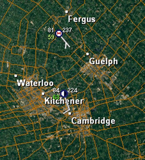
We recently re-added realtime METAR (Aviation Routine Weather Report) rosettes to the Scan B radar displays. The attached image shows the rosettes for Kithener-Waterloo and near Fergus, Ontario. These reporting stations are usually sited at airports and may or may not be automated. Their currency may lag by up to 2 hours, although they usually more current than that.
The rosette EWR displays consists of a centre circle, to which a wind vane is attached, and is surrounded by three or four numbers.
The centre dot may contain one of the following codes: M – no sky cover report (ie “missing”; a full white dot (clear sky), a full black dot (fully cloudy), or a partial black/white dot that is quartered in black and white in proportion to the relative cloud cover. In the image, the KW cloud cover is “50%”. Additionally, our METAR dots will also show a red down-arrow (sharply decreasing pressure) or a green up-arrow (sharply rising pressure). These latter two items report in relation to storm cells typically. The outer rim of a storm cell will be strongly high pressure due to the storm cell downdrafts and outflow winds, while the storm centre or core will show a strong low pressure due to rising air in the cell. These rapid changes are indicative of a strong convection cell, and should be viewed as indicative of potentially severe weather imminent.
The wind vane radiating from the centre dot indicates direction the wind is coming from; the “feathers”, the strength of the wind, in knots. There are two scale lengths to the feathers, long and short. A long feather is 10 knots, a short feather, 5 knots. The vane itself represents a 5 knot breeze.
The top left number in white is the reported temperature in degrees Fahrenheit. The lower green number is the dew point. The upper right number is the last 3 digits of the atmospheric pressure in kilopascals, ie, for Fergus, “237” is 1023.7 kpl.
Other chart symbols may show from time to time (we have no control over what comes down the METAR feed) – this chart link will show the many symbols which may turn up, depending on what’s on the feed at the time.
2014-06-11: Hurricane Cristina has now reached hurricane strength, and is on a course that takes it away from the mainland. Other than high surf, there is little risk to land atr this time.
2014-06-10:Newly formed Tropical Storm Cristina poses a possible threat the Mexican coast in the Eastern Pacific. Approximately 150mi. offshore this morning, Cristina is currently only producing a high surf. Risk of intensification to hurricane strength is real based on atmospheric conditions in its northwesterly path. It is expected to move out away from the coast.


BULLETIN
HURRICANE CRISTINA ADVISORY NUMBER 11
NWS NATIONAL HURRICANE CENTER MIAMI FL EP032014
200 AM PDT THU JUN 12 2014
…CRISTINA RAPIDLY INTENSIFIES INTO A CATEGORY THREE HURRICANE…
SUMMARY OF 200 AM PDT…0900 UTC…INFORMATION
———————————————-
LOCATION…16.2N 106.5W
ABOUT 240 MI…390 KM SW OF MANZANILLO MEXICO
MAXIMUM SUSTAINED WINDS…120 MPH…195 KM/H
PRESENT MOVEMENT…WNW OR 295 DEGREES AT 8 MPH…13 KM/H
MINIMUM CENTRAL PRESSURE…960 MB…28.35 INCHES
WATCHES AND WARNINGS
——————–
THERE ARE NO COASTAL WATCHES OR WARNINGS IN EFFECT.
DISCUSSION AND 48-HOUR OUTLOOK
——————————
AT 200 AM PDT…0900 UTC…THE CENTER OF HURRICANE CRISTINA WAS
LOCATED NEAR LATITUDE 16.2 NORTH…LONGITUDE 106.5 WEST. CRISTINA IS
MOVING TOWARD THE WEST-NORTHWEST NEAR 8 MPH…13 KM/H…AND THIS
GENERAL MOTION IS EXPECTED FOR THE NEXT COUPLE OF DAYS.
SATELLITE IMAGES INDICATE THAT THE MAXIMUM SUSTAINED WINDS HAVE
INCREASED TO NEAR 120 MPH…195 KM/H…WITH HIGHER GUSTS. CRISTINA
IS A CATEGORY THREE HURRICANE ON THE SAFFIR-SIMPSON HURRICANE WIND
SCALE. LITTLE SIGNIFICANT CHANGE IN STRENGTH IS FORECAST TODAY…AND
WEAKENING IS EXPECTED ON FRIDAY.
CRISTINA IS A SMALL CYCLONE. HURRICANE FORCE WINDS EXTEND OUTWARD
UP TO 15 MILES…30 KM…FROM THE CENTER…AND TROPICAL STORM FORCE
WINDS EXTEND OUTWARD UP TO 80 MILES…130 KM.
THE ESTIMATED MINIMUM CENTRAL PRESSURE IS 960 MB…28.35 INCHES.
HAZARDS AFFECTING LAND
———————-
SURF…SWELLS GENERATED BY CRISTINA ARE AFFECTING PORTIONS OF THE
SOUTHWESTERN COAST OF MEXICO. THESE SWELLS WILL LIKELY CONTINUE
THROUGH LATE TODAY…AND COULD CAUSE LIFE-THREATENING SURF AND RIP
CURRENT CONDITIONS. PLEASE CONSULT PRODUCTS FROM YOUR LOCAL WEATHER
OFFICE.
HURRICANE CRISTINA DISCUSSION NUMBER 11
NWS NATIONAL HURRICANE CENTER MIAMI FL EP032014
200 AM PDT THU JUN 12 2014
Satellite images indicate that Cristina has rapidly intensified
during the past several hours. Convection around the center has
become more intense and symmetric, with the eye also becoming better
defined and warmer. Dvorak estimates range from 102-112 kt, and 105
kt is chosen as the initial wind speed. Cirrus clouds approaching
the storm from the southwest suggest an increase in shear is coming
sooner rather than later, so only a small intensification is
predicted today. A weakening trend should begin on Friday due to
increasing southwesterly shear and cooler waters, with Cristina
likely transitioning into a remnant low over the cool eastern
Pacific waters by day 5. The NHC intensity forecast is higher than
the previous one in the short term to account for the initial
intensity, but is otherwise unchanged beyond 36 hours.
Cristina is moving at 295/7 around the southern periphery of a
mid-level high over Mexico. A west-northwestward to northwestward
motion is forecast during the next few days while the hurricane
remains steered by the high. Cristina should turn toward the west
and decelerate over the weekend when the weakening cyclone becomes
more steered by the low-level flow. Although there is still some
model disagreement at long range, the model consensus is almost
unchanged from the previous one, and the new NHC forecast is
basically an update of the last prediction.
Cristina is the earliest second major hurricane formation in the
eastern Pacific since reliable records began in 1971, eclipsing the
former record of Darby (2010) by 13 days.
FORECAST POSITIONS AND MAX WINDS
INIT 12/0900Z 16.2N 106.5W 105 KT 120 MPH
12H 12/1800Z 16.7N 107.5W 110 KT 125 MPH
24H 13/0600Z 17.5N 108.9W 105 KT 120 MPH
36H 13/1800Z 18.3N 110.1W 95 KT 110 MPH
48H 14/0600Z 19.0N 111.3W 80 KT 90 MPH
72H 15/0600Z 19.7N 112.8W 60 KT 70 MPH
96H 16/0600Z 20.0N 114.0W 45 KT 50 MPH
120H 17/0600Z 20.0N 116.0W 30 KT 35 MPH…POST-TROP/REMNT LOW

